Geolocate

Menomonie topographic map

Click on the map to display elevation.

About this map

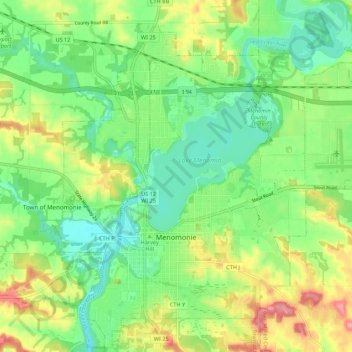
Name: Menomonie topographic map, elevation, terrain.

Location: Menomonie, Dunn County, Wisconsin, 54751, United States (44.85116 -91.96198 44.92632 -91.85286)

Average elevation: 273 m

Minimum elevation: 234 m

Maximum elevation: 337 m

Gear up for your next adventure:

🥾Waterproof Trail Shoes - Shoes designed to handle wet terrain
🔦LED Flashlight - Powerful and long-lasting flashlight for camping and emergencies
🧥Ultralight Puffy Jacket - Maximum warmth that packs down to the size of an orange
❄️Traction Ice Cleats - Slip-on spikes for icy trails and winter hiking
🧥Thermal Layer - Insulating layer for cold outdoor conditions

As an Amazon Associate, this site earns from qualifying purchases at no extra cost to you.