
Farkha topographic map
Click on the map to display elevation.
About this map
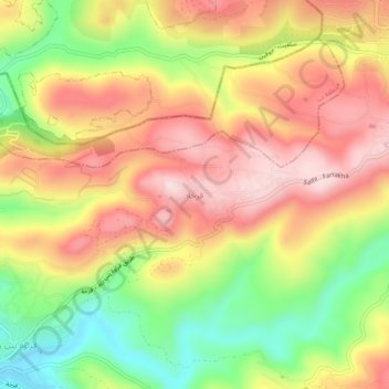
Name: Farkha topographic map, elevation, terrain.
Location: Farkha, Area A, West Bank, 390, Palestinian Territory (32.04890 35.13028 32.08890 35.17028)
Average elevation: 454 m
Minimum elevation: 283 m
Maximum elevation: 597 m
Other topographic maps
Click on a map to view its topography, its elevation and its terrain.
Ramallah
Palestinian Territory > Area A
Ramallah (UK: /rəˈmælə/ rə-MAL-ə, US: /rəˈmɑːlə/ rə-MAH-lə; Arabic: رام الله, romanized: Rām Allāh, lit. 'God's Height') is a Palestinian city in the central West Bank that serves as the de facto administrative capital of the State of Palestine. It is situated on the Judaean Mountains,…
Average elevation: 795 m
Nablus
Palestinian Territory > Area A
Insofar as the hilly topography of the site would allow, the city was built on a Roman grid plan and settled with veterans who fought in the victorious legions and other foreign colonists. In the 2nd century CE, Emperor Hadrian built a grand theater in Neapolis that could seat up to 7,000 people. Coins found…
Average elevation: 645 m
Bethlehem
Palestinian Territory > Area A
Bethlehem is located at an elevation of about 775 meters (2,543 ft) above sea level, 30 meters (98 ft) higher than nearby Jerusalem. Bethlehem is situated on the Judean Mountains.
Average elevation: 705 m
Bethlehem
Palestinian Territory > Area A
Bethlehem is located at an elevation of about 775 meters (2,543 ft) above sea level, 30 meters (98 ft) higher than nearby Jerusalem. Bethlehem is situated on the Judean Mountains.
Average elevation: 705 m
Bethlehem
Palestinian Territory > Area A
Bethlehem is located at an elevation of about 775 meters (2,543 ft) above sea level, 30 meters (98 ft) higher than nearby Jerusalem. Bethlehem is situated on the Judean Mountains.
Average elevation: 705 m
Meithalun
Palestinian Territory > Area A > Meithalun
The town is situated along the western edge of Marj Sanur, a valley and seasonal lake. It is the largest locality, of seven total, bordering Marj Sanur and controls the largest share of its fertile lands. It has an average elevation of 385 meters above sea level and is not elevated from its immediate…
Average elevation: 403 m