Geolocate

Montefiascone topographic map

Click on the map to display elevation.

About this map

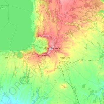
Name: Montefiascone topographic map, elevation, terrain.

Location: Montefiascone, Viterbo, Lazio, 01027, Italy (42.46224 11.95113 42.60214 12.09484)

Average elevation: 375 m

Minimum elevation: 211 m

Maximum elevation: 633 m

Other topographic maps

Click on a map to view its topography, its elevation and its terrain.

Monte Raschio

Italy > Lazio > Viterbo > Oriolo Romano

Average elevation: 448 m

Bagnaia

Italy > Lazio > Viterbo > Viterbo

Average elevation: 464 m

Isola Bisentina

Italy > Lazio > Viterbo > Capodimonte

Average elevation: 304 m

Cura

Italy > Lazio > Viterbo > Vetralla

Average elevation: 393 m

Gear up for your next adventure:

🦟Insect Repellent - Keep mosquitoes and black flies away in wooded areas
💡LED Camping Lantern - Illuminate your campsite with long-lasting lanterns
👟Trail Running Shoes - Agile footwear for fast-paced topographic exploration
🧥Softshell Hiking Jacket - The perfect balance of wind protection and breathability
🔨Vehicle Emergency Tool - Safety tool for remote road trips to trailheads

As an Amazon Associate, this site earns from qualifying purchases at no extra cost to you.