Geolocate

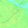
Hunts Crossroads topographic map

Click on the map to display elevation.

About this map

Name: Hunts Crossroads topographic map, elevation, terrain.

Location: Hunts Crossroads, Darlington County, South Carolina, United States (34.41210 -80.06729 34.45210 -80.02729)

Average elevation: 73 m

Minimum elevation: 51 m

Maximum elevation: 111 m

Other topographic maps

Click on a map to view its topography, its elevation and its terrain.

Gear up for your next adventure:

🦯Trekking Poles - Reduced impact on joints for steep topographic climbs
🏃Hydration Running Vest - Carry water and maps close to your body for speed
🧥Thermal Fleece Jacket - Versatile insulation for changing mountain temperatures
🧣Evaporative Cooling Towel - Beat the heat during intense summer climbs
🕶️Polarized Sunglasses - Protect your eyes with durable polarized lenses

As an Amazon Associate, this site earns from qualifying purchases at no extra cost to you.