
Make a donation
Gear up for your next adventure:
As an Amazon Associate, this site earns from qualifying purchases at no extra cost to you.
Klüt topographic map
Click on the map to display elevation.
Make a donation
Gear up for your next adventure:
As an Amazon Associate, this site earns from qualifying purchases at no extra cost to you.
About this map
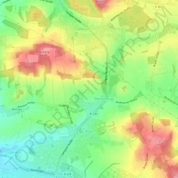
Name: Klüt topographic map, elevation, terrain.
Location: Klüt, Detmold, Kreis Lippe, Nordrhein-Westfalen, Deutschland (51.95315 8.88262 51.98763 8.93253)
Average elevation: 187 m
Minimum elevation: 131 m
Maximum elevation: 252 m
Make a donation
Gear up for your next adventure:
As an Amazon Associate, this site earns from qualifying purchases at no extra cost to you.
Other topographic maps
Click on a map to view its topography, its elevation and its terrain.
Make a donation
Gear up for your next adventure:
As an Amazon Associate, this site earns from qualifying purchases at no extra cost to you.
Stemberg
Deutschland > Nordrhein-Westfalen > Kreis Lippe > Detmold > Berlebeck
Average elevation: 266 m
Lippischer Meierhof
Deutschland > Nordrhein-Westfalen > Kreis Lippe > Detmold
Average elevation: 179 m
Make a donation
Gear up for your next adventure:
As an Amazon Associate, this site earns from qualifying purchases at no extra cost to you.