
Starks topographic map
Click on the map to display elevation.
About this map
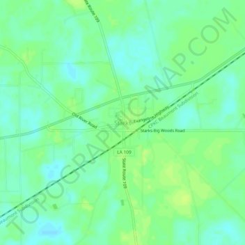
Name: Starks topographic map, elevation, terrain.
Location: Starks, Calcasieu Parish, Louisiana, 70661, United States (30.29559 -93.68184 30.33559 -93.64184)
Average elevation: 8 m
Minimum elevation: 1 m
Maximum elevation: 14 m
Other topographic maps
Click on a map to view its topography, its elevation and its terrain.
Lake Charles
United States > Louisiana > Calcasieu Parish
Lake Charles, located on a level plain about 30 miles (48 km) from the Gulf of Mexico, has an elevation of approximately 13 feet (4.0 m) above sea level, and is located on the banks of the Calcasieu River in southwestern Louisiana. It borders both Lake Charles and Prien Lake. Contraband Bayou, Henderson Bayou,…
Average elevation: 5 m
Lake Charles
United States > Louisiana > Calcasieu Parish
Lake Charles, located on a level plain about 30 miles (48 km) from the Gulf of Mexico, has an elevation around 13 feet (4.0 meters) above sea level, and is located on the banks of the Calcasieu River in southwestern Louisiana. It borders both Lake Charles and Prien Lake. Contraband Bayou, Henderson Bayou, and…
Average elevation: 5 m