
Pincher Creek topographic map
Interactive map
Click on the map to display elevation.
About this map
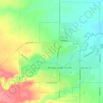
Name: Pincher Creek topographic map, elevation, terrain.
Location: Pincher Creek, Alberta, T0K 1W0, Canada (49.47368 -113.97167 49.50941 -113.91425)
Average elevation: 1,149 m
Minimum elevation: 1,109 m
Maximum elevation: 1,210 m
Other topographic maps
Click on a map to view its topography, its elevation and its terrain.
Pincher Creek
Canada > Alberta > Pincher Creek > Pincher Creek
Pincher Creek, Alberta, T0K 1W0, Canada
Average elevation: 1,171 m