
Make a donation
Gear up for your next adventure:
As an Amazon Associate, this site earns from qualifying purchases at no extra cost to you.
Skowhegan topographic map
Click on the map to display elevation.
Make a donation
Gear up for your next adventure:
As an Amazon Associate, this site earns from qualifying purchases at no extra cost to you.
Skowhegan
According to the United States Census Bureau, the town has a total area of 60.47 square miles (156.62 km2), of which 58.85 square miles (152.42 km2) is land and 1.62 square miles (4.20 km2) is water. Skowhegan is drained by the Wesserunsett Stream and Kennebec River. Loomis Hill, elevation 870 feet (270 meters) above sea level, is the highest point in town.
Make a donation
Gear up for your next adventure:
As an Amazon Associate, this site earns from qualifying purchases at no extra cost to you.
About this map
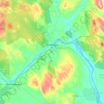
Name: Skowhegan topographic map, elevation, terrain.
Location: Skowhegan, Somerset County, Maine, United States (44.68690 -69.75999 44.82438 -69.58099)
Average elevation: 101 m
Minimum elevation: 29 m
Maximum elevation: 260 m
Make a donation
Gear up for your next adventure:
As an Amazon Associate, this site earns from qualifying purchases at no extra cost to you.
Other topographic maps
Click on a map to view its topography, its elevation and its terrain.
No Name Pond
United States > Maine > Somerset County > Bald Mountain Township T4 R3
Average elevation: 686 m
Make a donation
Gear up for your next adventure:
As an Amazon Associate, this site earns from qualifying purchases at no extra cost to you.