
Kilsby topographic map
Click on the map to display elevation.
About this map
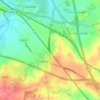
Name: Kilsby topographic map, elevation, terrain.
Location: Kilsby, West Northamptonshire, England, United Kingdom (52.31841 -1.20604 52.36128 -1.14181)
Average elevation: 129 m
Minimum elevation: 96 m
Maximum elevation: 174 m
Other topographic maps
Click on a map to view its topography, its elevation and its terrain.
Lower Thorpe
United Kingdom > England > West Northamptonshire > Thorpe Mandeville
Average elevation: 154 m
Ravensthorpe Reservoir
United Kingdom > England > West Northamptonshire > Coton
Average elevation: 131 m