Geolocate

American Fork topographic map

Click on the map to display elevation.

American Fork

Elevations throughout the city range from 4,566 feet (1,392 m) to 4,619 feet (1,408 m) above sea level.

Wikipedia (CC-BY-SA 3.0)

About this map

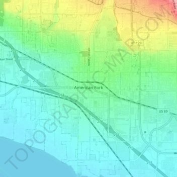
Name: American Fork topographic map, elevation, terrain.

Location: American Fork, Utah County, Utah, 84003, United States (40.34104 -111.83628 40.41170 -111.76361)

Average elevation: 1,405 m

Minimum elevation: 1,366 m

Maximum elevation: 1,537 m

Other topographic maps

Click on a map to view its topography, its elevation and its terrain.

Kyhv Peak

United States > Utah > Utah County

Average elevation: 1,995 m

Wildwood

United States > Utah > Utah County

Average elevation: 1,879 m

Townsend

United States > Utah > Utah County > Genola > Townsend

Average elevation: 1,438 m

Provo

United States > Utah > Utah County > Provo

Average elevation: 1,733 m

Gear up for your next adventure:

💧Hydration Bladder - Hands-free hydration solution for long treks
🧊Insulated Water Bottle - Keeps drinks cold in summer and prevents freezing in winter
👟Trail Running Shoes - Agile footwear for fast-paced topographic exploration
🛶Kayak Dry Bag - Waterproof storage for kayaking adventures
🧥Waterproof Pants - Keep dry during rainy hiking conditions

As an Amazon Associate, this site earns from qualifying purchases at no extra cost to you.