Geolocate

Laneast topographic map

Click on the map to display elevation.

About this map

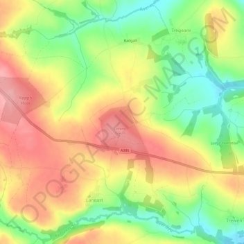
Name: Laneast topographic map, elevation, terrain.

Location: Laneast, Cornwall, England, United Kingdom (50.62200 -4.52961 50.65748 -4.47181)

Average elevation: 196 m

Minimum elevation: 133 m

Maximum elevation: 253 m

Gear up for your next adventure:

🧥Thermal Layer - Insulating layer for cold outdoor conditions
🧰Multitool Knife - Compact and versatile tool for outdoor use
🚲MTB Frame Bag - Carry tools and maps directly on your bicycle frame
🕶️Polarized Sunglasses - Protect your eyes with durable polarized lenses
🔋Emergency Crank Radio - Weather alerts and power without needing batteries

As an Amazon Associate, this site earns from qualifying purchases at no extra cost to you.