
Make a donation
Gear up for your next adventure:
As an Amazon Associate, this site earns from qualifying purchases at no extra cost to you.
Göcek topographic map
Click on the map to display elevation.
Make a donation
Gear up for your next adventure:
As an Amazon Associate, this site earns from qualifying purchases at no extra cost to you.
About this map
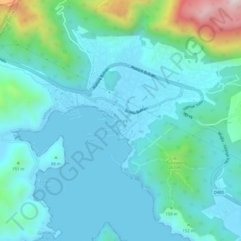
Name: Göcek topographic map, elevation, terrain.
Location: Göcek, Fethiye, Muğla, Aegean Region, 48310, Turkey (36.73371 28.92229 36.77371 28.96229)
Average elevation: 106 m
Minimum elevation: 0 m
Maximum elevation: 646 m
Make a donation
Gear up for your next adventure:
As an Amazon Associate, this site earns from qualifying purchases at no extra cost to you.
Other topographic maps
Click on a map to view its topography, its elevation and its terrain.
Oludeniz
Ölüdeniz offer a variety of diving opportunities with regard to its crystal clear waters and rich underwater caves and fauna. Scuba diving is the most popular underwater activity. Local diving agencies provide courses and required scuba diving licences. Snorkelling is another diving activity and many sites…
Average elevation: 541 m
Make a donation
Gear up for your next adventure:
As an Amazon Associate, this site earns from qualifying purchases at no extra cost to you.