
Montalbo topographic map
Interactive map
Click on the map to display elevation.
About this map
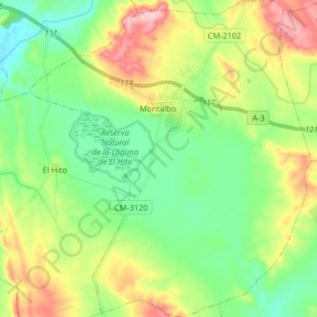
Name: Montalbo topographic map, elevation, terrain.
Location: Montalbo, Cuenca, Castilla-La Mancha, 16440, España (39.81078 -2.72589 39.91433 -2.60591)
Average elevation: 864 m
Minimum elevation: 806 m
Maximum elevation: 971 m
Other topographic maps
Click on a map to view its topography, its elevation and its terrain.
Laguna de El Hito
España > Castilla-La Mancha > Montalbo
Laguna de El Hito, CM-3120, Montalbo, Cuenca, Castilla-La Mancha, 16440, España
Average elevation: 837 m