Geolocate

Ananad Bagh topographic map

Click on the map to display elevation.

About this map

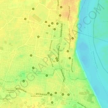
Name: Ananad Bagh topographic map, elevation, terrain.

Location: Ananad Bagh, Varanasi, Sadar, Varanasi, Uttar Pradesh, India (25.28865 83.00003 25.28931 83.00079)

Average elevation: 75 m

Minimum elevation: 56 m

Maximum elevation: 86 m

Other topographic maps

Click on a map to view its topography, its elevation and its terrain.

Sigra

India > Uttar Pradesh > Sadar > Varanasi

Average elevation: 81 m

Susuwahi

India > Uttar Pradesh > Sadar > Varanasi

Average elevation: 80 m

Sabji Mandi

India > Uttar Pradesh > Sadar > Varanasi

Average elevation: 81 m

Gear up for your next adventure:

🔥Emergency Fire Starter - Reliable ignition source for all weather conditions
🥾Mountain Trail Shoes - High-traction shoes for mountain trails
🔋Emergency Crank Radio - Weather alerts and power without needing batteries
🧣Merino Neck Gaiter - Protects against wind, sun, and cold at high altitudes
🎒Fully Waterproof Backpack - Total protection for photography gear and electronics

As an Amazon Associate, this site earns from qualifying purchases at no extra cost to you.