Geolocate

Trizac topographic map

Click on the map to display elevation.

About this map
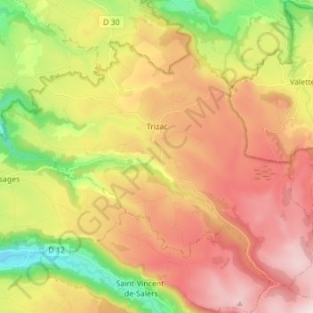
Name: Trizac topographic map, elevation, terrain.

Location: Trizac, Mauriac, Cantal, Auvergne-Rhône-Alpes, Metropolitan France, 15400, France (45.20337 2.46999 45.28480 2.60781)

Average elevation: 945 m

Minimum elevation: 562 m

Maximum elevation: 1,311 m

Other topographic maps

Click on a map to view its topography, its elevation and its terrain.
Lidar

France > Auvergne-Rhône-Alpes > Cantal > Brezons

Average elevation: 1,048 m

Le Foirail

France > Auvergne-Rhône-Alpes > Cantal > Salers

Average elevation: 862 m

Super Lioran

France > Auvergne-Rhône-Alpes > Cantal

Average elevation: 1,367 m

Ramon

France > Auvergne-Rhône-Alpes > Cantal > Boisset

Average elevation: 480 m

Lidar

France > Auvergne-Rhône-Alpes > Cantal > Brezons

Average elevation: 1,048 m

Puy Mary

France > Auvergne-Rhône-Alpes > Cantal > Le Falgoux

Average elevation: 1,413 m

Laborne

France > Auvergne-Rhône-Alpes > Cantal > Marcolès

Average elevation: 691 m

Passevite

France > Auvergne-Rhône-Alpes > Cantal > Rouziers

Average elevation: 519 m

La Tulière

France > Auvergne-Rhône-Alpes > Cantal > Trémouille

Average elevation: 890 m

La Bastide

France > Auvergne-Rhône-Alpes > Cantal > Laveissière

Average elevation: 1,111 m

Gear up for your next adventure:

🔨Vehicle Emergency Tool - Safety tool for remote road trips to trailheads
🏕️Camping Hammock - Integrated protection for sleeping between trees
🥾Waterproof Hiking Shoes - Durable shoes for wet and rugged trails
🥾Hiking Leggings - Comfortable leggings for outdoor activities
🔭Compact Binoculars - Lightweight optics for scouting trails and wildlife

As an Amazon Associate, this site earns from qualifying purchases at no extra cost to you.