Geolocate

Pigcawayan topographic map

Click on the map to display elevation.

About this map

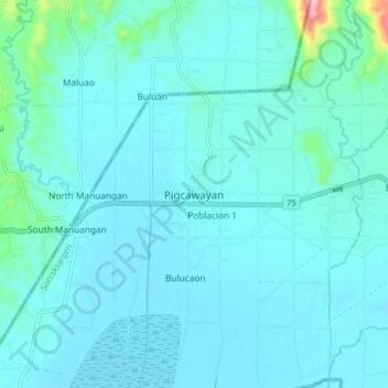
Name: Pigcawayan topographic map, elevation, terrain.

Location: Pigcawayan, North Cotabato, Soccsksargen, 9412, Philippines (7.23858 124.38428 7.31858 124.46428)

Average elevation: 27 m

Minimum elevation: 0 m

Maximum elevation: 277 m

Other topographic maps

Click on a map to view its topography, its elevation and its terrain.

Lake Jordan

Philippines > North Cotabato > Makilala

Average elevation: 2,383 m

President Roxas

Philippines > North Cotabato

Average elevation: 364 m

Gear up for your next adventure:

🚲Bike Repair Kit - Essential tools for on-trail mechanical issues
👟Leg Gaiters - Keep debris, mud, and snow out of your boots
🚑Survival Whistle - Signal for help across long distances in mountains
Camping Essentials - All-in-one gear for a comfortable camping trip
🥽Outdoor Goggles - Protective eyewear for outdoor activities

As an Amazon Associate, this site earns from qualifying purchases at no extra cost to you.