Geolocate

Pomorie topographic map

Click on the map to display elevation.

About this map

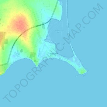
Name: Pomorie topographic map, elevation, terrain.

Location: Pomorie, Burgas, 8200, Bulgaria (42.52841 27.57678 42.60841 27.65678)

Average elevation: 5 m

Minimum elevation: -6 m

Maximum elevation: 40 m

Other topographic maps

Click on a map to view its topography, its elevation and its terrain.

Sunny Beach

Bulgaria > Burgas > Nesebar

Average elevation: 0 m

Gear up for your next adventure:

🧴Waterproofing Spray - Restore the DWR coating on jackets and tents
🛶Waterproof Dry Bags - Keep electronics and clothes dry during river crossings
🥾Mountain Hiking Boots - High-traction boots for rocky terrain
🧥Waterproof Pants - Keep dry during rainy hiking conditions
🩹Compact First Aid Kit - Pre-packed essentials for common trail injuries

As an Amazon Associate, this site earns from qualifying purchases at no extra cost to you.