
Thank you for supporting this site ❤️
Make a donation
Make a donation
Gear up for your next adventure:
As an Amazon Associate, this site earns from qualifying purchases at no extra cost to you.
Pleiku Ward topographic map
Click on the map to display elevation.
Thank you for supporting this site ❤️
Make a donation
Make a donation
Gear up for your next adventure:
As an Amazon Associate, this site earns from qualifying purchases at no extra cost to you.
About this map
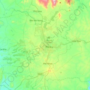
Name: Pleiku Ward topographic map, elevation, terrain.
Location: Pleiku Ward, Phường Pleiku, Gia Lai Province, 61111, Vietnam (13.81734 107.84020 14.13734 108.16020)
Average elevation: 709 m
Minimum elevation: 459 m
Maximum elevation: 1,458 m
Thank you for supporting this site ❤️
Make a donation
Make a donation
Gear up for your next adventure:
As an Amazon Associate, this site earns from qualifying purchases at no extra cost to you.
Other topographic maps
Click on a map to view its topography, its elevation and its terrain.
quang truong dai doan ket
Vietnam > Gia Lai Province > Phường Pleiku > Pleiku Ward
Average elevation: 755 m