
Los Ríos Region topographic map
Click on the map to display elevation.
About this map
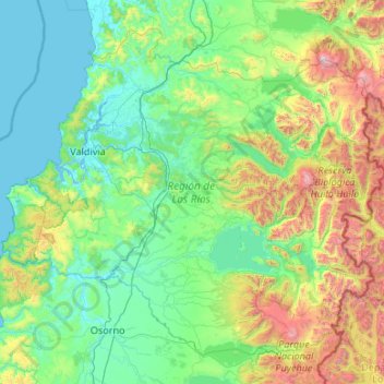
Name: Los Ríos Region topographic map, elevation, terrain.
Location: Los Ríos Region, Chile (-40.68097 -73.72509 -39.28735 -71.59266)
Average elevation: 431 m
Minimum elevation: -2 m
Maximum elevation: 2,781 m
Other topographic maps
Click on a map to view its topography, its elevation and its terrain.
Parque Rio Colina Norte
Chile > Santiago Metropolitan Region > Provincia de Chacabuco > Colina
Average elevation: 672 m
Farellones
Chile > Santiago Metropolitan Region > Provincia de Santiago > Lo Barnechea
Average elevation: 2,243 m
Punta Arenas
Chile > Region of Magallanes and Chilean Antarctica > Provincia de Magallanes > Punta Arenas
Average elevation: 122 m
Monte Fitz Roy
Chile > Region of Magallanes and Chilean Antarctica > Provincia de Última Esperanza > Puerto Natales
Average elevation: 2,023 m
Toconao
Chile > Antofagasta Region > Provincia de El Loa > San Pedro de Atacama
Toconao is a village 38 km (24 mi) south of San Pedro de Atacama in the San Pedro de Atacama province of Chile's northern Antofagasta Region. It lies at an elevation of 2,485 m (8,153 ft) above sea level, close to the northeast margin of the Salar de Atacama.
Average elevation: 2,488 m
Oficina Pedro de Valdivia
Chile > Antofagasta Region > Provincia de Tocopilla > María Elena
Average elevation: 1,445 m
Cerro Cazador
Chile > Region of Magallanes and Chilean Antarctica > Provincia de Última Esperanza > Torres del Paine
Average elevation: 824 m
Flor del Desierto
Chile > Tarapacá Region > Provincia del Tamarugal > Pozo Almonte
Average elevation: 1,031 m
Villa Alegre
Chile > Santiago Metropolitan Region > Provincia de Melipilla > Melipilla
Average elevation: 144 m
Oficina Lagunas
Chile > Tarapacá Region > Provincia del Tamarugal > Pozo Almonte
Average elevation: 870 m
Cape Horn
Chile > Magallanes and Chilean Antarctica Region > Provincia de la Antártica Chilena > Cape Horn
Average elevation: 40 m
Bellavista
Chile > Valparaiso Region > Provincia de San Felipe de Aconcagua > San Felipe
Average elevation: 637 m
Bajos de Matte
Chile > Santiago Metropolitan Region > Provincia de Maipo > Buin
Average elevation: 482 m
Aduana de Cuya
Chile > Arica and Parinacota Region > Provincia de Arica > Camarones
Average elevation: 314 m
Porvenir
Chile > Region of Magallanes and Chilean Antarctica > Provincia de Tierra del Fuego > Porvenir > Porvenir
Average elevation: 38 m
Cerro Santiago Benadava
Chile > Region of Magallanes and Chilean Antarctica > Provincia de la Antártica Chilena > Cape Horn
Average elevation: 928 m
Puerto Williams
Chile > Region of Magallanes and Chilean Antarctica > Provincia de la Antártica Chilena > Cape Horn
The climate of Puerto Williams is a temperate subpolar oceanic climate (Cfc) bordering closely on a tundra climate (ET) according to the Köppen climate classification. The summers are short and cool while the winters are long, wet, but moderate. Rainfall is around 512.3 mm (20 in) a year and temperatures are…
Average elevation: 151 m
Cerro Pereda
Chile > Antofagasta Region > Provincia de Antofagasta > Taltal
Average elevation: 4,246 m
El Salado
Chile > Atacama Region > Provincia de Chañaral > Chañaral > El Salado
Average elevation: 488 m
Monte Almirante Nieto
Chile > Region of Magallanes and Chilean Antarctica > Provincia de Última Esperanza > Torres del Paine
Average elevation: 1,973 m