
Make a donation
Gear up for your next adventure:
As an Amazon Associate, this site earns from qualifying purchases at no extra cost to you.
Toconao topographic map
Click on the map to display elevation.
Make a donation
Gear up for your next adventure:
As an Amazon Associate, this site earns from qualifying purchases at no extra cost to you.
Toconao
Toconao is a village 38 km (24 mi) south of San Pedro de Atacama in the San Pedro de Atacama province of Chile's northern Antofagasta Region. It lies at an elevation of 2,485 m (8,153 ft) above sea level, close to the northeast margin of the Salar de Atacama.
Make a donation
Gear up for your next adventure:
As an Amazon Associate, this site earns from qualifying purchases at no extra cost to you.
About this map
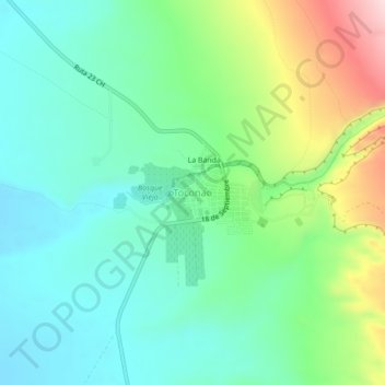
Name: Toconao topographic map, elevation, terrain.
Average elevation: 2,488 m
Minimum elevation: 2,397 m
Maximum elevation: 2,711 m
Make a donation
Gear up for your next adventure:
As an Amazon Associate, this site earns from qualifying purchases at no extra cost to you.