
Garderen topographic map
Interactive map
Click on the map to display elevation.
About this map
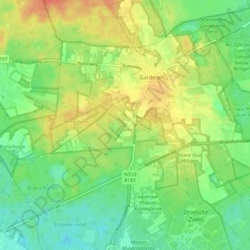
Name: Garderen topographic map, elevation, terrain.
Location: Garderen, Barneveld, Geldern, Niederlande (52.20385 5.65766 52.24250 5.74303)
Average elevation: 34 m
Minimum elevation: 13 m
Maximum elevation: 61 m
Other topographic maps
Click on a map to view its topography, its elevation and its terrain.
De Glind
Niederlande > Geldern > Barneveld
De Glind, Barneveld, Geldern, Niederlande
Average elevation: 7 m
Kootwijk
Niederlande > Geldern > Barneveld
Kootwijk, Barneveld, Geldern, Niederlande
Average elevation: 29 m