
Kootwijk topographic map
Interactive map
Click on the map to display elevation.
About this map
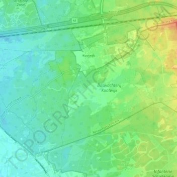
Name: Kootwijk topographic map, elevation, terrain.
Location: Kootwijk, Barneveld, Geldern, Niederlande (52.14760 5.70486 52.19699 5.81193)
Average elevation: 29 m
Minimum elevation: 16 m
Maximum elevation: 50 m
Other topographic maps
Click on a map to view its topography, its elevation and its terrain.
De Glind
Niederlande > Geldern > Barneveld
De Glind, Barneveld, Geldern, Niederlande
Average elevation: 7 m
Garderen
Niederlande > Geldern > Barneveld
Garderen, Barneveld, Geldern, Niederlande
Average elevation: 34 m