
Make a donation
Gear up for your next adventure:
As an Amazon Associate, this site earns from qualifying purchases at no extra cost to you.
Vacas topographic map
Click on the map to display elevation.
Make a donation
Gear up for your next adventure:
As an Amazon Associate, this site earns from qualifying purchases at no extra cost to you.
Vacas
La localidad se encuentra al centro del municipio de Vacas. Asimismo, se halla en las alturas del Cono Sur cochabambino, a una altitud de 3.475 m s. n. m. Y está a una distancia de 84 km de la ciudad de Cochabamba y a 30 km de la localidad de Arani.
Make a donation
Gear up for your next adventure:
As an Amazon Associate, this site earns from qualifying purchases at no extra cost to you.
About this map
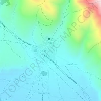
Name: Vacas topographic map, elevation, terrain.
Location: Vacas, Municipio Vacas, Arani, Cochabamba, Bolivia (-17.57849 -65.58449 -17.57078 -65.57753)
Average elevation: 3,508 m
Minimum elevation: 3,414 m
Maximum elevation: 3,847 m
Make a donation
Gear up for your next adventure:
As an Amazon Associate, this site earns from qualifying purchases at no extra cost to you.
Other topographic maps
Click on a map to view its topography, its elevation and its terrain.
Laguna Juntutuyo
Bolivia > Cochabamba > Arani > Municipio Vacas > Cocha Chimpa
Average elevation: 3,448 m