
Make a donation
Gear up for your next adventure:
As an Amazon Associate, this site earns from qualifying purchases at no extra cost to you.
Toro Warkhu topographic map
Click on the map to display elevation.
Make a donation
Gear up for your next adventure:
As an Amazon Associate, this site earns from qualifying purchases at no extra cost to you.
About this map
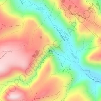
Name: Toro Warkhu topographic map, elevation, terrain.
Location: Toro Warkhu, Municipio Vacas, Arani, Cochabamba, Bolivia (-17.63586 -65.51471 -17.63550 -65.51422)
Average elevation: 3,499 m
Minimum elevation: 3,278 m
Maximum elevation: 3,684 m
Make a donation
Gear up for your next adventure:
As an Amazon Associate, this site earns from qualifying purchases at no extra cost to you.
Other topographic maps
Click on a map to view its topography, its elevation and its terrain.
Vacas
Bolivia > Cochabamba > Arani > Municipio Vacas
La localidad se encuentra al centro del municipio de Vacas. Asimismo, se halla en las alturas del Cono Sur cochabambino, a una altitud de 3.475 m s. n. m. Y está a una distancia de 84 km de la ciudad de Cochabamba y a 30 km de la localidad de Arani.
Average elevation: 3,508 m