Geolocate

Sinagra topographic map

Click on the map to display elevation.

About this map

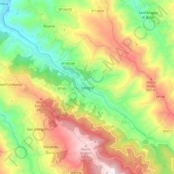
Name: Sinagra topographic map, elevation, terrain.

Location: Sinagra, Messina, Sicily, 98069, Italy (38.05860 14.80089 38.10801 14.89437)

Average elevation: 547 m

Minimum elevation: 60 m

Maximum elevation: 1,140 m

Other topographic maps

Click on a map to view its topography, its elevation and its terrain.

Castel di Tusa

Italy > Sicily > Messina

Average elevation: 96 m

Monte Serro

Italy > Sicily > Messina > Messina

Average elevation: 92 m

Sperone

Italy > Sicily > Messina > Messina

Average elevation: 56 m

Messina

Italy > Sicily > Messina > Messina

Average elevation: 180 m

Gear up for your next adventure:

🛌Down Sleeping Bag - Superior warmth-to-weight ratio for cold nights
🔥Camping Stove - Portable stoves to cook outdoors with ease
🥾Trekking Boots - Durable boots for long-distance trekking
🧥Waterproof Hiking Jacket - Protect yourself from rain and wind while hiking
🧭Orienteering Kit - Tools for map reading and navigation in the wild

As an Amazon Associate, this site earns from qualifying purchases at no extra cost to you.