
Make a donation
Gear up for your next adventure:
As an Amazon Associate, this site earns from qualifying purchases at no extra cost to you.
Sudrach topographic map
Click on the map to display elevation.
Make a donation
Gear up for your next adventure:
As an Amazon Associate, this site earns from qualifying purchases at no extra cost to you.
About this map
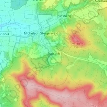
Name: Sudrach topographic map, elevation, terrain.
Average elevation: 359 m
Minimum elevation: 270 m
Maximum elevation: 478 m
Make a donation
Gear up for your next adventure:
As an Amazon Associate, this site earns from qualifying purchases at no extra cost to you.
Other topographic maps
Click on a map to view its topography, its elevation and its terrain.
Werneck
Germany > Bavaria > Landkreis Schweinfurt
Werneck lies in the Lower Franconia region of Bavaria, approximately 12 km from Schweinfurt and 25 km from Würzburg. It is located on a bend in the Wern, a tributary of the Main, on the edge of the plateau above the river. Its highest point is at 337.20 m of elevation, its lowest at 212.50 m. The total area…
Average elevation: 256 m
Make a donation
Gear up for your next adventure:
As an Amazon Associate, this site earns from qualifying purchases at no extra cost to you.
Make a donation
Gear up for your next adventure:
As an Amazon Associate, this site earns from qualifying purchases at no extra cost to you.