
Euerbach topographic map
Click on the map to display elevation.
About this map
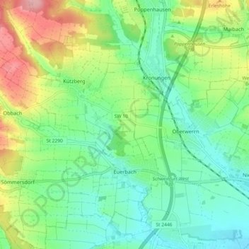
Name: Euerbach topographic map, elevation, terrain.
Location: Euerbach, Landkreis Schweinfurt, Bavaria, 97502, Germany (50.04382 10.05933 50.10175 10.14790)
Average elevation: 266 m
Minimum elevation: 224 m
Maximum elevation: 351 m
Other topographic maps
Click on a map to view its topography, its elevation and its terrain.
Michelau i.Steigerwald
Germany > Bavaria > Landkreis Schweinfurt > Michelau i.Steigerwald
Average elevation: 333 m