Geolocate

Toora topographic map

Click on the map to display elevation.

About this map

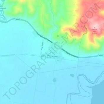
Name: Toora topographic map, elevation, terrain.

Location: Toora, Shire of South Gippsland, Victoria, 3962, Australia (-38.68474 146.30435 -38.64474 146.34435)

Average elevation: 50 m

Minimum elevation: -3 m

Maximum elevation: 259 m

Gear up for your next adventure:

🧴Sunscreen SPF - Broad-spectrum sunscreen for outdoor activities
🏃Hydration Running Vest - Carry water and maps close to your body for speed
Camping Tent - Weather-resistant tents suitable for 2 to 6 people
🐕Hiking Dog Pack - Let your canine companion carry their own water and food
🥘Camping Cookware Set - Compact nesting pots and pans for trail cooking

As an Amazon Associate, this site earns from qualifying purchases at no extra cost to you.