Geolocate

Endon Bank topographic map

Click on the map to display elevation.

About this map

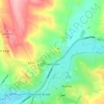
Name: Endon Bank topographic map, elevation, terrain.

Location: Endon Bank, Endon and Stanley, Endon, Staffordshire Moorlands, Staffordshire, England, ST9 9HP, United Kingdom (53.06154 -2.13350 53.10154 -2.09350)

Average elevation: 192 m

Minimum elevation: 133 m

Maximum elevation: 286 m

Other topographic maps

Click on a map to view its topography, its elevation and its terrain.

Gear up for your next adventure:

🥾Lightweight Hiking Shoes - Comfortable shoes for day hikes
❄️Traction Ice Cleats - Slip-on spikes for icy trails and winter hiking
🏃Hydration Running Vest - Carry water and maps close to your body for speed
🔭Compact Binoculars - Lightweight optics for scouting trails and wildlife
🔋Lithium AA Batteries - Long-lasting power that performs in extreme cold

As an Amazon Associate, this site earns from qualifying purchases at no extra cost to you.