Geolocate

Tarapoto topographic map

Click on the map to display elevation.

About this map
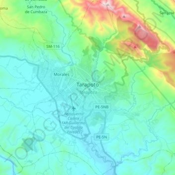
Name: Tarapoto topographic map, elevation, terrain.

Location: Tarapoto, Province of San Martín, San Martín, Peru (-6.56879 -76.40972 -6.41253 -76.33334)

Average elevation: 464 m

Minimum elevation: 206 m

Maximum elevation: 1,619 m

Other topographic maps

Click on a map to view its topography, its elevation and its terrain.
Morro de Calzada

Peru > San Martín > Calzada > Calzada

Average elevation: 961 m

Rey del Valle

Peru > San Martín > Alonso de Alvarado

Average elevation: 1,197 m

Guantanamo

Peru > San Martín

Average elevation: 559 m

La Unión

Peru > San Martín > La Banda de Shilcayo

Average elevation: 429 m

San Andrés

Peru > San Martín > Jepelacio

Average elevation: 1,275 m

Gear up for your next adventure:

💡LED Camping Lantern - Illuminate your campsite with long-lasting lanterns
🧥Ultralight Puffy Jacket - Maximum warmth that packs down to the size of an orange
🔥Camping Stove - Portable stoves to cook outdoors with ease
💧Hydration Bladder - Hands-free hydration solution for long treks
🧊Portable Cooler - Keep food and drinks cold during outdoor adventures

As an Amazon Associate, this site earns from qualifying purchases at no extra cost to you.