Geolocate

Erstfeld topographic map

Click on the map to display elevation.

About this map
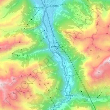
Name: Erstfeld topographic map, elevation, terrain.

Location: Erstfeld, Uri, 6472, Switzerland (46.77637 8.51750 46.84932 8.68303)

Average elevation: 1,476 m

Minimum elevation: 444 m

Maximum elevation: 3,173 m

Other topographic maps

Click on a map to view its topography, its elevation and its terrain.

Biel

Switzerland > Uri > Bürglen (UR)

Average elevation: 1,521 m

Eggstock

Switzerland > Uri > Göschenen

Average elevation: 3,052 m

Klausenpass

Switzerland > Uri > Unterschächen

Klausen Pass (German: Klausenpass; elevation: 1,948 metres or 6,391 feet) is a high mountain pass in the Swiss Alps connecting Altdorf in the canton of Uri with Linthal in the canton of Glarus. Somewhat unusually, the boundary between the two cantons does not lie at the summit of the pass, but some 8…

Average elevation: 2,103 m

Amsteg

Switzerland > Uri

Average elevation: 1,051 m

Oberalp

Switzerland > Uri > Unterschächen

Average elevation: 1,900 m

Unterdorf

Switzerland > Uri > Seedorf (UR)

Average elevation: 739 m

Rossbodenstock

Switzerland > Uri > Korporation Ursern > Andermatt

Average elevation: 2,392 m

Mittleren Seck

Switzerland > Uri > Erstfeld

Average elevation: 2,265 m

Oberalppass

Switzerland > Uri > Korporation Ursern > Andermatt

Average elevation: 2,219 m

Arnisee

Switzerland > Uri > Gurtnellen

Average elevation: 1,289 m

Gear up for your next adventure:

🥽Outdoor Goggles - Protective eyewear for outdoor activities
👟Sport Hiking Sandals - Breathable footwear for water crossings and camp rest
🧥Thermal Layer - Insulating layer for cold outdoor conditions
💧Filtered Water Bottle - Safe drinking water on the go
🚲MTB Frame Bag - Carry tools and maps directly on your bicycle frame

As an Amazon Associate, this site earns from qualifying purchases at no extra cost to you.