Geolocate

Unterdorf topographic map

Click on the map to display elevation.

About this map

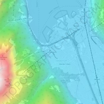
Name: Unterdorf topographic map, elevation, terrain.

Location: Unterdorf, Seedorf (UR), Uri, 6462, Switzerland (46.86544 8.58626 46.90544 8.62626)

Average elevation: 739 m

Minimum elevation: 428 m

Maximum elevation: 2,334 m

Gear up for your next adventure:

🧴Bear Spray Holster - Quick-access carry for essential Canadian wilderness safety
🛶Canoe Life Vest - Safety vest for water sports
🧣Evaporative Cooling Towel - Beat the heat during intense summer climbs
💧Hydration Bladder - Hands-free hydration solution for long treks
🥫Freeze-Dried Meals - Lightweight, high-calorie nutrition for multi-day treks

As an Amazon Associate, this site earns from qualifying purchases at no extra cost to you.