Geolocate

Haidhäuser topographic map

Click on the map to display elevation.

About this map

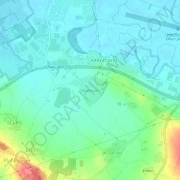
Name: Haidhäuser topographic map, elevation, terrain.

Location: Haidhäuser, Cham, Landkreis Cham, Bayern, Deutschland (49.19930 12.63381 49.20463 12.64208)

Average elevation: 381 m

Minimum elevation: 364 m

Maximum elevation: 434 m

Other topographic maps

Click on a map to view its topography, its elevation and its terrain.

Chammünster

Deutschland > Bayern > Landkreis Cham > Cham

Average elevation: 399 m

Selling

Deutschland > Bayern > Landkreis Cham > Cham > Kothmaißling

Average elevation: 399 m

Haidhäuser

Deutschland > Bayern > Landkreis Cham > Cham

Average elevation: 383 m

Vilzing

Deutschland > Bayern > Landkreis Cham > Cham

Average elevation: 422 m

Haderstadl

Deutschland > Bayern > Landkreis Cham > Cham

Average elevation: 439 m

Gutmaning

Deutschland > Bayern > Landkreis Cham > Cham

Average elevation: 412 m

Gear up for your next adventure:

🧦Crew Hiking Socks - Comfortable socks for long-distance hikes
🔋Solar Power Bank - Keep your GPS and devices charged during long outdoor trips
🥾Hiking Leggings - Comfortable leggings for outdoor activities
🧦Outdoor Socks - Durable socks designed for hiking and outdoor sports
🧥Insulated Jacket - Keep warm in cold outdoor conditions

As an Amazon Associate, this site earns from qualifying purchases at no extra cost to you.