
Make a donation
Gear up for your next adventure:
As an Amazon Associate, this site earns from qualifying purchases at no extra cost to you.
Haidhäuser topographic map
Click on the map to display elevation.
Make a donation
Gear up for your next adventure:
As an Amazon Associate, this site earns from qualifying purchases at no extra cost to you.
About this map
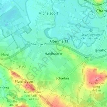
Name: Haidhäuser topographic map, elevation, terrain.
Location: Haidhäuser, Cham, Landkreis Cham, Bayern, 93413, Deutschland (49.18184 12.61893 49.22184 12.65893)
Average elevation: 383 m
Minimum elevation: 360 m
Maximum elevation: 444 m
Make a donation
Gear up for your next adventure:
As an Amazon Associate, this site earns from qualifying purchases at no extra cost to you.
Other topographic maps
Click on a map to view its topography, its elevation and its terrain.
Schwedenschanze
Deutschland > Bayern > Landkreis Cham > Cham > Chammünster
Der Burgstall Schwedenschanze, bei der es sich vermutlich um die Reichsburg Cham handelt, ist eine abgegangene Höhenburg (Wallburg) auf dem 415 Meter hohen Galgenberg 35 Meter über dem Zusammenfluss von Chamb und Regen in der Gemarkung Altenstadt der Stadt Cham im oberpfälzischen Landkreis Cham in Bayern.…
Average elevation: 385 m