
Biwabik topographic map
Click on the map to display elevation.
About this map
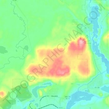
Name: Biwabik topographic map, elevation, terrain.
Location: Biwabik, Saint Louis County, Minnesota, 55708, United States (47.52342 -92.38597 47.60332 -92.27241)
Average elevation: 461 m
Minimum elevation: 411 m
Maximum elevation: 565 m
Other topographic maps
Click on a map to view its topography, its elevation and its terrain.
Chris Lake
United States > Minnesota > Saint Louis County > Pequaywan Township
Average elevation: 494 m
Embarrass
United States > Minnesota > Saint Louis County > Embarrass Township
Average elevation: 438 m
Tower Junction
United States > Minnesota > Saint Louis County > Breitung Township > Soudan
Average elevation: 437 m
Norway Creek
United States > Minnesota > Saint Louis County > Northeast St Louis
Average elevation: 424 m
Central Lakes
United States > Minnesota > Saint Louis County > Ellsburg Township
Average elevation: 408 m
Echo River
United States > Minnesota > Saint Louis County > Northeast St Louis
Average elevation: 393 m
Embarrass
United States > Minnesota > Saint Louis County > Embarrass Township
Average elevation: 438 m