Geolocate

Hunters Park topographic map

Click on the map to display elevation.

About this map

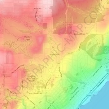
Name: Hunters Park topographic map, elevation, terrain.

Location: Hunters Park, Duluth, Saint Louis County, Minnesota, 55812, United States (46.80911 -92.09324 46.84911 -92.05324)

Average elevation: 333 m

Minimum elevation: 179 m

Maximum elevation: 433 m

Other topographic maps

Click on a map to view its topography, its elevation and its terrain.

Riverside

United States > Minnesota > Saint Louis County > Duluth

Average elevation: 244 m

West Duluth

United States > Minnesota > Saint Louis County > Duluth

West Duluth covers an area of 5,726 acres (23 km2), or 13% of the city area, making it the third-largest district in the city. Note that, as with many other Duluth neighborhood districts, the area actually developed to a major extent is considerably smaller than the district figure. This is largely due to the…

Average elevation: 252 m

Woodland

United States > Minnesota > Saint Louis County > Duluth

Average elevation: 396 m

Oneota

United States > Minnesota > Saint Louis County > Duluth

Average elevation: 187 m

Gear up for your next adventure:

🥘Camping Cookware Set - Compact nesting pots and pans for trail cooking
🧣Evaporative Cooling Towel - Beat the heat during intense summer climbs
🧴First Aid Kit - Essential first aid supplies for outdoor emergencies
🔋Solar Power Bank - Keep your GPS and devices charged during long outdoor trips
🥾Mountain Trail Shoes - High-traction shoes for mountain trails

As an Amazon Associate, this site earns from qualifying purchases at no extra cost to you.