Geolocate

Vidra topographic map

Click on the map to display elevation.

About this map
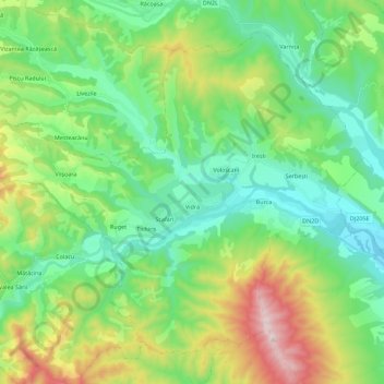
Name: Vidra topographic map, elevation, terrain.

Location: Vidra, Vrancea, Romania (45.85007 26.77863 45.98103 27.00245)

Average elevation: 413 m

Minimum elevation: 181 m

Maximum elevation: 982 m

Other topographic maps

Click on a map to view its topography, its elevation and its terrain.

Cătăuți

Romania > Vrancea

Average elevation: 426 m

Dălhăuți

Romania > Vrancea

Average elevation: 277 m

Câmpuri

Romania > Vrancea

Average elevation: 424 m

Măgura Odobești

Romania > Vrancea

Average elevation: 802 m

Boțârlău

Romania > Vrancea

Average elevation: 27 m

Coza

Romania > Vrancea

Average elevation: 560 m

Rucăreni

Romania > Vrancea

Average elevation: 576 m

Lepșa

Romania > Vrancea

Average elevation: 747 m

Podu Lacului

Romania > Vrancea

Average elevation: 319 m

Coza

Romania > Vrancea

Average elevation: 535 m

Gear up for your next adventure:

🧰Emergency Multi-Tool - Compact multi-tool for outdoor survival
🥘Camping Cookware Set - Compact nesting pots and pans for trail cooking
🛶Waterproof Dry Bags - Keep electronics and clothes dry during river crossings
🎒Hiking Backpack - Lightweight and ergonomic backpacks for day hikes or multi-day treks
🥾Durable Hiking Shoes - Long-lasting shoes for frequent hiking

As an Amazon Associate, this site earns from qualifying purchases at no extra cost to you.