Geolocate

Podu Lacului topographic map

Click on the map to display elevation.

About this map

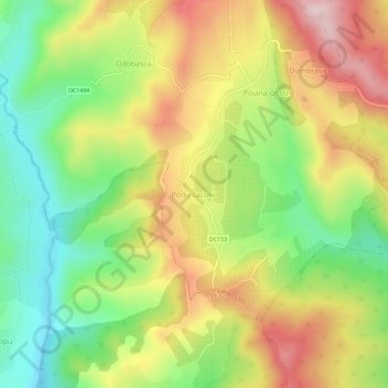
Name: Podu Lacului topographic map, elevation, terrain.

Location: Podu Lacului, Poiana Cristei, Vrancea, 627272, Romania (45.62352 26.96978 45.66352 27.00978)

Average elevation: 319 m

Minimum elevation: 166 m

Maximum elevation: 495 m

Other topographic maps

Click on a map to view its topography, its elevation and its terrain.

Biliești

Romania > Vrancea

Average elevation: 33 m

Odobești

Romania > Vrancea

Average elevation: 220 m

Mera

Romania > Vrancea

Average elevation: 449 m

Câmpuri

Romania > Vrancea

Average elevation: 503 m

Coza

Romania > Vrancea

Average elevation: 535 m

Poiana Cristei

Romania > Vrancea

Average elevation: 348 m

Odobești

Romania > Vrancea

Average elevation: 220 m

Năruja

Romania > Vrancea

Average elevation: 499 m

Focșani

Romania > Vrancea

Average elevation: 59 m

Tulnici

Romania > Vrancea

Average elevation: 683 m

Adjud

Romania > Vrancea

Adjud is situated on a plain and is surrounded by hills up to a height of 400 meters at the foot of the southern Carpathians. The average altitude of the town is 100 m above sea level. The surrounding land is favorable for agriculture.

Average elevation: 138 m

Gear up for your next adventure:

🥾Light Trekking Boots - Supportive boots for multi-day treks
🥾Mountain Trail Shoes - High-traction shoes for mountain trails
🧼Travel Hand Sanitizer - Keep hands clean when water is scarce
🗺️Topographic Maps - Detailed maps to explore trails, mountains, and wilderness areas
🎒Hiking Backpack - Lightweight and ergonomic backpacks for day hikes or multi-day treks

As an Amazon Associate, this site earns from qualifying purchases at no extra cost to you.