Geolocate

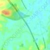
Boambee topographic map

Click on the map to display elevation.

About this map

Name: Boambee topographic map, elevation, terrain.

Location: Boambee, Coffs Harbour, New South Wales, Australia (-30.35127 153.02817 -30.31447 153.08923)

Average elevation: 18 m

Minimum elevation: -1 m

Maximum elevation: 186 m

Other topographic maps

Click on a map to view its topography, its elevation and its terrain.
Red Hill

Australia > New South Wales > Coffs Harbour

Average elevation: 118 m

Dunvegan

Australia > New South Wales > Coffs Harbour

Average elevation: 165 m

Landrigans

Australia > New South Wales > Coffs Harbour

Average elevation: 157 m

Gear up for your next adventure:

🧢Outdoor Cap - Protective cap for sun and rain during hikes
🧥Insulated Jacket - Keep warm in cold outdoor conditions
🎒Fully Waterproof Backpack - Total protection for photography gear and electronics
🛶Waterproof Dry Bags - Keep electronics and clothes dry during river crossings
🚑Survival Whistle - Signal for help across long distances in mountains

As an Amazon Associate, this site earns from qualifying purchases at no extra cost to you.