Geolocate

Acrefair topographic map

Click on the map to display elevation.

About this map

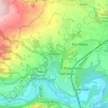
Name: Acrefair topographic map, elevation, terrain.

Location: Acrefair, Wrexham, Wales, LL14 3SF, United Kingdom (52.96049 -3.10048 53.00049 -3.06048)

Average elevation: 149 m

Minimum elevation: 46 m

Maximum elevation: 341 m

Other topographic maps

Click on a map to view its topography, its elevation and its terrain.

Gwersyllt

United Kingdom > Wales > Wrexham

Average elevation: 112 m

Penycae

United Kingdom > Wales > Wrexham

Average elevation: 350 m

Rhosddu

United Kingdom > Wales > Wrexham

Average elevation: 88 m

Bangor-on-Dee

United Kingdom > Wales > Wrexham

Average elevation: 30 m

Cefn

United Kingdom > Wales > Wrexham > Acrefair

Average elevation: 142 m

Gear up for your next adventure:

🥾Mountain Trail Shoes - High-traction shoes for mountain trails
🥾Mountain Hiking Shoes - Shoes with superior grip for mountainous terrain
🥤Collapsible Travel Cup - Saves space and weight in your mess kit
🛶Waterproof Dry Bags - Keep electronics and clothes dry during river crossings
🧢Sun Hat - Wide-brim hat for sun protection

As an Amazon Associate, this site earns from qualifying purchases at no extra cost to you.