Geolocate

Selmont topographic map

Click on the map to display elevation.

About this map

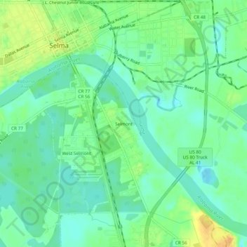
Name: Selmont topographic map, elevation, terrain.

Location: Selmont, Dallas County, Alabama, 36702, United States (32.37514 -87.02832 32.41514 -86.98832)

Average elevation: 35 m

Minimum elevation: 23 m

Maximum elevation: 54 m

Other topographic maps

Click on a map to view its topography, its elevation and its terrain.

Selma

United States > Alabama > Dallas County

Average elevation: 40 m

l

United States > Alabama > Dallas County > Selma

Average elevation: 36 m

Gear up for your next adventure:

🥾Trail Hiking Boots - Supportive boots for rough trails
Lightweight Camping Tent - Portable shelter optimized for Canadian backcountry camping
🐕Hiking Dog Pack - Let your canine companion carry their own water and food
🥾All-Terrain Hiking Boots - Versatile boots for varied hiking conditions
🥾Trail Running Shoes - Lightweight and durable shoes for trail running

As an Amazon Associate, this site earns from qualifying purchases at no extra cost to you.