Geolocate

Bjärred topographic map

Click on the map to display elevation.

About this map

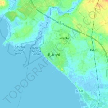
Name: Bjärred topographic map, elevation, terrain.

Location: Bjärred, Lomma kommun, Skåne County, 237 31, Sweden (55.68219 12.98164 55.76219 13.06164)

Average elevation: 5 m

Minimum elevation: -3 m

Maximum elevation: 30 m

Other topographic maps

Click on a map to view its topography, its elevation and its terrain.

Höganäs kommun

Sweden > Skåne County

Average elevation: 13 m

Skurups kommun

Sweden > Skåne County

Average elevation: 23 m

Svedala kommun

Sweden > Skåne County

Average elevation: 40 m

Gear up for your next adventure:

🧴Outdoor Sunscreen - High SPF protection for high-altitude UV exposure
💡Portable Camping Lamp - Rechargeable lamp for campsite lighting
Family Camping Tent - Spacious tent suitable for family camping trips
🏃Hydration Running Vest - Carry water and maps close to your body for speed
🥾Approach Boots - Comfortable boots for hiking and climbing approaches

As an Amazon Associate, this site earns from qualifying purchases at no extra cost to you.