
Make a donation
Gear up for your next adventure:
As an Amazon Associate, this site earns from qualifying purchases at no extra cost to you.
Needles topographic map
Click on the map to display elevation.
Make a donation
Gear up for your next adventure:
As an Amazon Associate, this site earns from qualifying purchases at no extra cost to you.
About this map
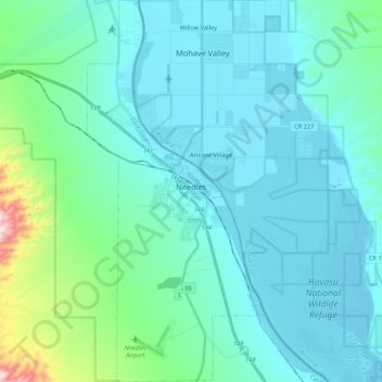
Name: Needles topographic map, elevation, terrain.
Location: Needles, San Bernardino County, California, United States (34.74845 -114.66230 34.92420 -114.56188)
Average elevation: 221 m
Minimum elevation: 138 m
Maximum elevation: 772 m
Make a donation
Gear up for your next adventure:
As an Amazon Associate, this site earns from qualifying purchases at no extra cost to you.
Other topographic maps
Click on a map to view its topography, its elevation and its terrain.
Sam Alba Memorial Park
United States > California > San Bernardino County > Ontario
Average elevation: 296 m
Make a donation
Gear up for your next adventure:
As an Amazon Associate, this site earns from qualifying purchases at no extra cost to you.