
Denbigh topographic map
Interactive map
Click on the map to display elevation.
About this map
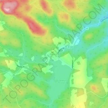
Name: Denbigh topographic map, elevation, terrain.
Average elevation: 379 m
Minimum elevation: 312 m
Maximum elevation: 479 m
Lennox and Addington County trails, hiking, mountain biking, running and outdoor activities
Other topographic maps
Click on a map to view its topography, its elevation and its terrain.
Grimsthorpe Lake
Canada > Ontario > Lennox and Addington County > Addington Highlands
Average elevation: 336 m
Denbigh Lake
Canada > Ontario > Lennox and Addington County > Addington Highlands > Denbigh
Average elevation: 372 m
Upper Mazinaw Lake
Canada > Ontario > Lennox and Addington County > Addington Highlands
Average elevation: 296 m
Bon Echo Lake
Canada > Ontario > Lennox and Addington County > Addington Highlands
Average elevation: 313 m
Bon Echo Provincial Park
Canada > Ontario > Lennox and Addington County > Addington Highlands
Average elevation: 321 m