Geolocate

Arun topographic map

Click on the map to display elevation.

About this map

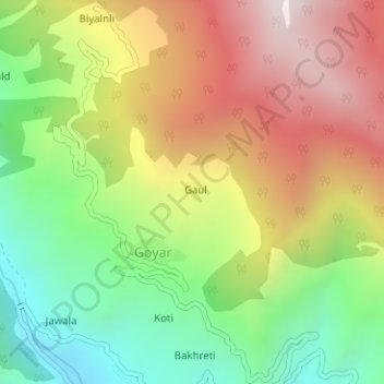
Name: Arun topographic map, elevation, terrain.

Location: Arun, Rajgarhi, Uttarkashi District, Uttarakhand, India (30.87636 78.20053 30.87766 78.20229)

Average elevation: 1,925 m

Minimum elevation: 1,423 m

Maximum elevation: 2,500 m

Other topographic maps

Click on a map to view its topography, its elevation and its terrain.

Gangani

India > Uttarakhand > Rajgarhi

Average elevation: 1,551 m

Barkot

India > Uttarakhand > Rajgarhi

Average elevation: 1,628 m

Syalna

India > Uttarakhand > Rajgarhi

Average elevation: 2,049 m

Gear up for your next adventure:

🥾Lightweight Hiking Shoes - Comfortable shoes for day hikes
🔋Lithium AA Batteries - Long-lasting power that performs in extreme cold
🦯Trekking Poles - Reduced impact on joints for steep topographic climbs
🛶Waterproof Dry Bags - Keep electronics and clothes dry during river crossings
👖Convertible Hiking Pants - Zip-off legs to adapt to changing weather conditions

As an Amazon Associate, this site earns from qualifying purchases at no extra cost to you.