
Localidad Riomar topographic map
Click on the map to display elevation.
About this map
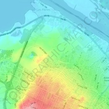
Name: Localidad Riomar topographic map, elevation, terrain.
Average elevation: 38 m
Minimum elevation: 0 m
Maximum elevation: 128 m
Other topographic maps
Click on a map to view its topography, its elevation and its terrain.
Parque Santander
Colombia > Atlántico > Barranquilla > Perímetro Urbano Barranquilla
Average elevation: 39 m
Bulevar de Simón Bolívar
Colombia > Atlántico > Barranquilla > Perímetro Urbano Barranquilla
Average elevation: 21 m
Parque La Solución
Colombia > Atlántico > Barranquilla > Perímetro Urbano Barranquilla
Average elevation: 31 m
Parque Montecristo
Colombia > Atlántico > Barranquilla > Perímetro Urbano Barranquilla
Average elevation: 20 m
Parque San Salvador
Colombia > Atlántico > Barranquilla > Perímetro Urbano Barranquilla
Average elevation: 23 m
Parque San Pio
Colombia > Atlántico > Barranquilla > Perímetro Urbano Barranquilla
Average elevation: 51 m