
Make a donation
Gear up for your next adventure:
As an Amazon Associate, this site earns from qualifying purchases at no extra cost to you.
Ixmiquilpan topographic map
Click on the map to display elevation.
Make a donation
Gear up for your next adventure:
As an Amazon Associate, this site earns from qualifying purchases at no extra cost to you.
Ixmiquilpan
The climate and topography of the municipal divide into two parts. The land is beautiful and many take hiking trips for fun since the climate is almost perfect. This is increasing tourism in the area. Many buses departing from Mexico City arrive to this destination and visitors spend time in the so famous water parks throughout the community. One well known park is El Parque Acuatico De Dios Padre. This particular park offers transportation, hotels, camping and services for tourists that come from Mexico City. Many immigrants that migrated to the U.S. in the 1980s as the result in shortages of farm labor in California are from this particular area. Now in their late 20s, many have now obtained a higher education in the U.S. and are now returning to their homeland in Ixmiquilpan. This has let to new entrepreneurship in the area. Small businesses of tourism and hotels can now be found across the city. The southern portion is dry with green areas only where there is irrigation. It is relatively flat. The north in squarely in the Mezquital Valley and is considerably higher, wetter and more mountainous. A mountain ridge separates the two sections. The highest elevations are found at the La Palma, Thito, Muñeca, Guadril, Temboo, Dexitzo and Daxhie Mountains. These and other mountains have forests which contain pine, oak, walnut and a number of other trees. The dry areas contain vegetation such as mesquite, nopal, palms and other plants adapted to arid areas. Much of the agriculture in the municipality occurs in the relatively flat south which relies on irrigation due to the lack of rainfall. Main crops are corn, beans, animal feed and tomatoes. Livestock raised includes cattle, pigs, sheep, goats, turkeys and bees. There is some fishing in the north, where water is abundant, but it is mostly for auto-consumption. Almost a third of the population of the municipality still speaks an indigenous language, and this is almost exclusively Otomí. This is especially true in the smaller communities such as San Alberto, located in one of the lower portions of the Mezquital Valley off the highway between Ixmiquilpan and El Progreso, near the Tula River. It is a village of about 700 people, all of whom speak Otomi and a number speak little or no Spanish. They are farmers, living off the harvests of corn, beans and other staples. It is a poor town, with roads in disrepair and no streetlights. While the village has been converting this fresh water and hot springs here into bathing pools to attract tourism, many of their young people go to the United States to work and send back money.
Make a donation
Gear up for your next adventure:
As an Amazon Associate, this site earns from qualifying purchases at no extra cost to you.
About this map
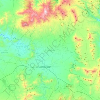
Name: Ixmiquilpan topographic map, elevation, terrain.
Location: Ixmiquilpan, Hidalgo, Mexico (20.36855 -99.29876 20.70886 -99.07921)
Average elevation: 1,984 m
Minimum elevation: 1,555 m
Maximum elevation: 3,177 m
Make a donation
Gear up for your next adventure:
As an Amazon Associate, this site earns from qualifying purchases at no extra cost to you.
Other topographic maps
Click on a map to view its topography, its elevation and its terrain.
Pachuca
Mexico > Hidalgo > Pachuca de Soto
Pachuca has a semi-arid climate (Köppen climate classification BSk). The climate is cool with high rainfall and occasional hail during the summer months and dry conditions during the winter. The coldest month is January, with an average high of 20 °C (68 °F) and an average low of 3 °C (37 °F). Winter…
Average elevation: 2,459 m
Make a donation
Gear up for your next adventure:
As an Amazon Associate, this site earns from qualifying purchases at no extra cost to you.
Santiago Tulantepec
Mexico > Hidalgo > Santiago Tulantepec de Lugo Guerrero
Average elevation: 2,260 m
Make a donation
Gear up for your next adventure:
As an Amazon Associate, this site earns from qualifying purchases at no extra cost to you.
Pachuca
Mexico > Hidalgo > Pachuca de Soto
Pachuca has a semi-arid climate (Köppen climate classification BSk). The climate is cool with high rainfall and occasional hail during the summer months and dry conditions during the winter. The coldest month is January, with an average high of 20 °C (68 °F) and an average low of 3 °C (37 °F). Winter…
Average elevation: 2,459 m
Make a donation
Gear up for your next adventure:
As an Amazon Associate, this site earns from qualifying purchases at no extra cost to you.
Make a donation
Gear up for your next adventure:
As an Amazon Associate, this site earns from qualifying purchases at no extra cost to you.
Col. Loma Bonita
Mexico > Hidalgo > Atotonilco de Tula > Atotonilco de Tula > Col. Loma Bonita
Average elevation: 2,164 m
Make a donation
Gear up for your next adventure:
As an Amazon Associate, this site earns from qualifying purchases at no extra cost to you.