
Ripe topographic map
Click on the map to display elevation.
About this map
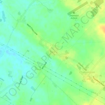
Name: Ripe topographic map, elevation, terrain.
Average elevation: 15 m
Minimum elevation: 3 m
Maximum elevation: 30 m
Other topographic maps
Click on a map to view its topography, its elevation and its terrain.
High Cross
United Kingdom > England > East Sussex > Wealden District > Rotherfield > High Cross
Average elevation: 129 m
Furner's Green
United Kingdom > England > East Sussex > Wealden District > Danehill > Furner's Green
Average elevation: 62 m
Three Cups Corner
United Kingdom > England > East Sussex > Wealden District > Punnett's Town
Average elevation: 110 m