
Bellefonte topographic map
Click on the map to display elevation.
About this map
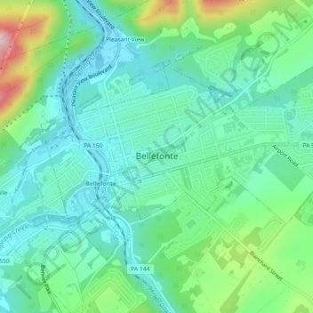
Name: Bellefonte topographic map, elevation, terrain.
Average elevation: 285 m
Minimum elevation: 216 m
Maximum elevation: 487 m
Other topographic maps
Click on a map to view its topography, its elevation and its terrain.
Dalevue Park
United States > Pennsylvania > Centre County > State College > Dalevue
Average elevation: 331 m
Loch Lomond Junction
United States > Pennsylvania > Centre County > Rush Township
Average elevation: 460 m