Geolocate

Chah Sultan topographic map

Click on the map to display elevation.

About this map

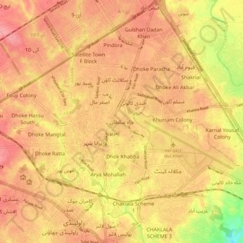
Name: Chah Sultan topographic map, elevation, terrain.

Location: Chah Sultan, Rawalpindi City Tehsil, Rawalpindi District, Rawalpindi Division, Punjab, 46300, Pakistan (33.58445 73.03243 33.66445 73.11243)

Average elevation: 506 m

Minimum elevation: 446 m

Maximum elevation: 534 m

Other topographic maps

Click on a map to view its topography, its elevation and its terrain.

Chakri

Pakistan > Punjab > Rawalpindi District

Average elevation: 354 m

Park

Pakistan > Punjab > Rawalpindi District

Average elevation: 479 m

Gear up for your next adventure:

🧰Multitool Knife - Compact and versatile tool for outdoor use
🥾Durable Hiking Shoes - Long-lasting shoes for frequent hiking
🥾Trail Running Boots - Durable shoes designed for trail running
💡Portable Camping Lamp - Rechargeable lamp for campsite lighting
🧭GPS Tracker - Track your location in remote areas safely

As an Amazon Associate, this site earns from qualifying purchases at no extra cost to you.